

Thursday, 25 August 2011
Red Sea and the unique running as a narrow
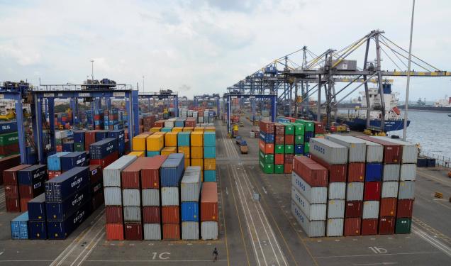
Open a port grand food street in Karachi

Thursday, 18 August 2011
karachi sea disaster
 Found the body of a giant whale entangled in fishing nets on the beach here Hawkesbay. Was stuck in the 20 feet long and 300 kg body of the dead whales up in fishing nets set up by local fishermen on the shore of Hawkesbay, near the village of Mubarak, and the nation learned on Monday.As in the details, a fisherman are Imam Box, a resident of Goth Abdul Rahman, Hawksbay set up a fishing net in the waters of the sea that kept lying there for the entire Sunday night. The following morning on Monday when a fisherman pulled the net they found a dead fish in their nets, they took on the beach.Responsible for the wetlands of the World Wide Fund for Nature, Pakistan, said Dr. Babar the nation that the dead whales and sharks about 20 feet long, which had died after being involved in the net. He was called the fish "in the Baluchi language Baran and Magar Andhi Sindhi language. On the other hand, local fishermen said Sikand this author that the fish do not belong dead whale shark, but the community was the whale.News of the dead whale has spread like wildfire, and the number of people rushed to the scene to see the dead whale. However, it reached any of the government officials there to convert or dump dead fish. Villagers said that the body was fetid, and appealed for the transformation of the body to fish elsewhere. Recently, found the bodies of a number of different types of whales on the shores of Sindh and Balochistan.There are several types of whales and dolphins on the coasts of the country, including, humpack whale, sperm whale, beaked whale, and the purpose finless, whale shark, dolphin spilner Similarly, closer to 20 species of whales.It was also another kind of dead fish, including whales and dolphins Huges Dottlenose, Risso dolphin, whale baleen and others found on the shore of Sindh and Balochistan in the past.There are many species of great whales of this kind in the Arabian Sea, including the Baluchistan and Oman.
karcahi port of dead fish!

"The dead fish started appearing on Saturday afternoon, but on Sunday night, the number of fish has increased alarmingly," said UC-4 Keamari City Councillor Abdul Ghani. He added that it was not only the dead fish, but the dead turtles have been spotted in this area as well."This is not the first time that thousands of small fish have died mysteriously in this area, but this time the number of fish are so high that it indicates a coming catastrophe in the Arabian Sea," said the 36, Muhammad Saleem, a fisherman from the village of Kakap. Although there are different varieties among the dead fish the majority are fish Mugil, known locally as Moore Machha, he said, adding that the size of dead fish varies between four inches to one and a half feet, they are and floating on the water outside the mangroves.Fishermen said the Lyari river carries toxic industrial waste that meets the sea near the settlement Machhar and, often, this waste is harmful if it causes a disaster of this magnitude. "If the authorities do not remove dead fish immediately, they will cause another disaster," said Haji Nawaz Mallah old."Whenever leaks highly toxic industrial waste into the river Lyari, fish die in the river and fishermen find them floating near Baba and the islands Bhitt, Kakap village Salehabadi island Shamspir Keamari island near the port of fish. We inform the authorities every time this happens, but they ignore us every time, "said Ghani. He added that the large amount of dead fish floating in the area is a common phenomenon during the full moon tides high. However, Ghani think something probably happened within the port, which killed so many fish and the authorities should investigate the KPT.Shamspir resident of village, Suliman, blamed the port authorities to allow trailers to take any deep sea fish in the open sea, leaving the local fishermen have no choice but to fish in coastal pollution. "We do not know what to do and how to make a living in such conditions. Many of us think of the evolution of our profession," he said.However, KPT officials rejected the claims of fishermen that the fish died of toxic chemicals. "This is the work of the Red Tide, locally known as" Mara Pani (Water killer). "This is normal and happens several times a year. There is no need to panic, "said the Karachi Port Trust (KPT) Responsible Marine Pollution Control, Muhammad Zahiya Usmani. He also denied that the dead fish in the harbor limits.
Sunday, 14 August 2011
gwadar is future Dubai

history of gwadar

Saturday, 13 August 2011
Port Muhammad Bin Qasim
 PQA has vast tracts of 13,770 acres of land for the development of existing industrial port complexes and commercial. Out of 13,770 acres of land has been allocated 3659 acres of services and facilities to leave an area 10,111 acres of the balance of the allocation. Have now been allocated 9012 acres for potential investors. The balance of 1099 acres and is generally low lying area and was devoted to warehouses and light industrial / heavy. The PQA is also an active role in promoting industrialization in the country. So far, 178 industrial and commercial complexes are already working in different areas, while it is 276 in the construction phase.Port Qasim Authority was established by an Act of Parliament in the June 29, 1973. 2 PQA is a deep sea operation of the industrial port status under the commercial concept of the owner. The port is located in the Indus River delta area about 28 nautical miles south-east of Karachi. PQA is the port the most environmentally friendly and geographically located on the trade route from the Persian Gulf. Port currently serves more than 40% of the requirements of the seaborne trade of the country.
Port management:
Port under the administrative control of Ministry of Transport Maritime ports, and the Government of Pakistan. President is the CEO of the port. And promote all policy decisions in the PQA Board comprises seven members, headed by Chairman, PQA. The Council is a combination of sector participation and public sectors.
Jobs:
PQA is primarily a service-oriented organization. Port facilities and provides services based on the shore lines of international shipping and other relevant agencies in the form of an adequate water depth in the channel, berths / terminals, cargo handling equipment, godowns, storage areas, and provide facilities for day to night and the safe passage of ships.
Site:
Day and night through the port access channel long after the 45 km channel marked by buoys up to 11 meters vessel draft.
Approach:
Day and night access to the port through a long canal, 45 km marked by channel buoys up to 11 meters vessel draft.
PQA has attracted both in the single port facilities and port-based industrial development. These advantages include:
Close to the cost of transport and thus provide the background.
First-rate multimedia communication with the network.
Time effecient port services and cost-effective.
Utilitie availability of basic necessities such as potable water, electricity, gas, telecommunications, banking and other facilities.
Enormous potential to expand the port facilities to meet the vital needs for international navigation.
Transit facilities and transit trade with Afghanistan and the republics of Central Asia.
A full range of port facilities to handle, and got in, bulk, and bulk and liquid cargo and containeized with backup facilities.
gwadar port
 Pakistan developing the port, and the hub econimic.Gwadar Port is the port the third of Pakistan .Karachi and Port Qasim being the other two. It is the first free trade port in Pakistan, and also the first deep sea port in the region as a whole. Gwadar on the borders of the Arabian Sea and is located in the province of Balochistan. It is about 533 km from Karachi and 120 km from the Iranian border. Gwadar Port is located at the entrance to the Persian Gulf and outside the Strait of Hormuz, where the vast majority of the world's oil passes every day. It's located near the main shipping routes used by the major vessels in the region, with links to Africa, Asia and Europe, and has high commercial importance and strategy.Various professional studies that show the port of Gwadar site is the most useful alternative outlet, which can handle ships and oil tankers, large Mother in time.Will serve as an incentive for a large number of related projects such as.
*Transshipment of bulk cargo
*Oil storage, refining and petrochemical
*Export processing and industrial zones
*Export of minerals / livestock
*Services (hotels, housing, tourism)
Distance from the Earth Gwadar:
Is located in Quetta, 970 km
Located in 164 km Turbat
Located at 120 km Gabd
Is located in Karachi, 533 km
Located at 892 km Ratodero
Purpose:
The purpose of developing this port to stimulate economic growth in the western and northern parts of Pakistan, and take advantage of the resources available from the coast of the country, and also provide an outlet for the landlocked countries in Central Asia and Afghanistan through transit trade, transshipment facilities provide.
Thursday, 11 August 2011
north western india coast,culture,food....

Homes :
Model built by the student's plankhouse
Most of the villages consisted of large rectangular houses. Each 30 to 40 people. Was made by covering a wide planked with two packages in the gabled north. Were often decorated with figures carved posts. Was divided by floors ground floor mats woven into family units. Several families lived in one of these large structures. They were allowed to each family of space about the size of the barn stall. And each family had its own fire, but did not participate cookfires in the center of the building. Beyond the southern cone roofs low. Homes built in the North race for both men and women, for men only in the south, stood a large totem poles carved from tree trunks in front of houses. Totem poles and showed the address of the head of the family.
Dress :
Wore clothes coastal northwest Indian bit. Except for long trips they went barefoot. The men wore fur hats or baskets. Rain heads wearing robes and leather fiber. The men wore rags behind. Men tattoo their arms and hands to measure dentalium. Dentalium shell was composed together, and use the funds.
Dressed women living in the Washington area fringed skirts cedar, bark or skin of goats. Elsewhere in a series of women wearing aprons fiber or lead aprons and back, the skin.
Women wore hats, baskets, rain heads and sleeveless jackets, dresses and some leather. Some of the women tattoo their chins. The clothing woven of strips of bark fiber.
Food :
Can coastal Northwest Indians fishing enough during the summer salmon run to feed themselves for the whole winter. Indians also caught a variety of food including halibut, cod, sea. Eat oysters and crabs, seals, sea otters, sea lions, and whales. Tracked and wild animals including men bear, caribou, deer, elk, and moose. In some areas can be found mountain goats. Women gathered roots, berries, seaweed and salt, nuts, mushrooms, nuts, bulbs Kamas. And some berries and berries favorites.
Customs :
Coastal tribes in the north west are sometimes gathered together for the potlatch. The person hosting the potlatch away many gifts to his guests as he can. Showed this was rich. These celebrations can last for several days. Singing, dancing, story-telling part of the celebration.
Took the coastal north-western Indian slaves. The slaves were a sign of wealth. And kept close to the camp for fear children would be stolen by another tribe and becomes a slave.
Tools / weapons :
Chase only two Indian tribes of coastal north-west, and Mecca and Nootka, for food in the sea. They built a large cruising boats. Some of the more than 60 feet long. On boats built of trunks of cedar trees and huge redwood. Boats can hold up to 60 men. In Mecca and Nootka carved in the pictures often painted and put designs on their own boats.
Build a large boat called an umiak Inuit. Umiak was about 30 feet in length. When a whale was seen was the first president to strike it with his bayonet. Then joined the others. After the whale died, the Indians tied to shut the mouths of the lungs so the whale can not be filled with water. And the whale become heavy and sink if this were to happen. Were withdrawn and then return the whale to the beach.
Once the whale was pulled to shore, and cut him. Been divided into the meat. Used as a source of whale oil and bone for the various tools. The whole tribe could live for a full year in 2-4 whales.
Art :
Northwest Indians believed that they are closely linked both in their families to a certain animal. The animals, common crow, Thunderbird, and the eagle, wolf, killer whale, and bear. And used these animals and designs for many of the objects. Flattened and in some cases, designs or bent in the form of object was being developed. Developed parts of the animals in the ovals square, solid curve-shaped sections of U.
Coastal north-western India, and carved wooden masks painted. These dances have been used during the celebrations. Acted outside the ancestral dances, legends and family assets. It seemed sometimes masked dancers through trap doors or swinging in the air on a rope to look like it was flying. The ceremony was held to set the details. When put on the masks, the dancers took on the character represented the spirit of the mask.
Chennai Port

Established M / s.Cogan and settlement of trading in a small fishing village of Chennaipattnam in 1639. East India Company chose this place English as a center of commercial activities in the south. And so laid the foundations of the modern city of Chennai, the capital of Tamilnadu. South Gate has developed this major commercial center, and is also linked through the water on the roads, rail and air with the rest of the world. But in those days when air travel was still unknown, and the sea route to Britain, and was the most important for transporting goods and people. The port of Chennai came into existence in those times, and began to flourish. In the early 19th century efforts to revive the trade by building the port, and improve shipping facilities. However, swept the sea on the breakwater in the port. And speed up the accumulation of silt at the bottom of the sea at the entrance and deposition of sand alarming proportions. Thus, the redesign was to address the port and wharf construction west of sidewalks, and transit sheds with two, along with the closure of the eastern entrance through the wall of vertical. Platform was created to deal with passenger traffic, and the movement of troops and horses on the import of the southern arm of the port and called in the south of the pavement.
kolkata port
Ran the Commissioners of the port of Calcutta port and until January 1975 when the main port Funds Act 1963, entered into force. Has been in the history of the port of Calcutta, the story of an ongoing struggle and success - it's a story of uninterrupted improvement and development and achievements. Not for nothing that he was able to overcome every target set and set all the records at the time of walking almost every activity of the port. Can be achieved only because of the professionalism and commitment to luxury. In the recent past, the port of Calcutta was judged as the best managed port in the fact that country.Despite 126 miles away from the sea, and Calcutta, so far, the best option for the eastern gateway to the country's continental shelf. Calcutta Port Trust is still one of the leading ports in India and promising. He is leading the vast remote areas, which includes nearly half of Indian states (all from the eastern and north-east) and the neighboring countries - in the Himalayan kingdoms of Nepal and Bhutan. Has organized the dock two - Calcutta Calcutta in the basin of the system with oil platforms in the BAJ BAJ and Haldia Dock Complex at Haldia - has a range of facilities with lots of attractive packages.
Calcutta Port Trust:
Kolkata is the oldest major port in the country. But the nucleus of the port of Calcutta today is much earlier - with the commercial rights granted to the settlement in the British East India by Emperor Aurangzeb Moghal. The city of Calcutta, has a cooperative relationship with the track time port.In the authority of government in this vast country passed from the East India Company to the British Crown. Brought to the port under the administrative control of the government with the appoinment of the port in 1870. Have been designed at the outset in the port of Calcutta for the promotion and protection of the British colonial interests. But with the advent of freedom in 1947, it was called, and called the port to act as an opposite to defend the national cause. Took more than one port of responsibility in the wake of the wake of World War II and the division of the country.
Tuesday, 9 August 2011
New Mangalore Port Trust:
Completion of fertilizers and major commodities exported through the port and concentrates, iron ore and pellets, fines and iron ore products, POL, and stones, granite and goods in containers, etc. The main imports to the port are crude and products POL, LPG, wood pulp and logs of wood, and liquid ammonia, phosphoric acid, and materials other liquid chemicals, goods in containers. Paradip Port Trust:
Paradip is one of the major ports in India and the main left and leave the other seaborne trade of the eastern part of the country divided into states like Orissa, Andhra Pradesh, Madhya Pradesh and Uttar Pradesh, Bihar and West Bengal. Natural resources and industrial products from these remote areas is widespread and enormous value of trade of the country's crude passing through the port of Paradip is considerably higher than many other major ports in India.
Been laying the foundation stone of the port of Pandit Jawaharlal Nehru that the January 3, 1962. And began construction of the November 19, 1962 and began dredging operations from March 15, 1964 by "VLASINA" Yugoslav bulldozer. During this period, and this was the port under the control of the state government of Orissa. And the Government of India took over the management of the port from the State Government in June 1, 1965. Was the completion of the pavement, iron ore and the Department of Immigration and Naturalization, "the investigator" I had the honor of calling at Mina al-Bakr in the March 12, 1966. Port declared open by Mr. Peter Stambolic, Prime Minister of Yugoslavia in the same day. The Government of India and the port of Paradip leading eighth of India on 18.04.1966 making it the first major port on the east coast commissioned in independent India.
Visakhapatnam Port Trust:
Hello Welcome to the port of Visakhapatnam, east coast and a gateway to India. It plays a crucial role as a distribution point for the southern Mediterranean, Eastern, central and northern states of India. As is shown the brightest jewel of all Indian major ports for its outstanding performance and productivity, Visakhapatnam Port serves as a catalyst in stimulating the domestic and international trade.
Visakhapatnam Port was built and placed 22 berths including the status of sidewalks raw art (2), off shore oil tanker terminals, liquefied petroleum gas dock and container terminal. We also build four new multi-purpose berths, two of which will be commissioned soon. We are also going to get the latest equipment for beach operations quickly. With the recently granted recognition to us in the international accreditation of quality management and safety and the environment, and we make significant changes to improve productivity and customer service.a
Subscribe to:
Comments (Atom)